Assessing current VHF propagation
Archive post.
Translated from Ukrainian.
To assess real propagation on VHF, just like on HF, people use beacons. For HF there’s, for example, the NCDXF/IARU International Beacon Project network.
On VHF the range is limited, so putting up a beacon every 100 km is expensive. That’s why propagation is monitored using signal sources that already exist, most often FM broadcast stations. But keeping track of every FM station is hard, and I don’t see how you’d spot a new distant station or tell it apart from a local one.
Radio amateur Jon Harder (NG0E) from Minnesota, USA, built a propagation service that watches packets on the APRS network. Every packet carries GPS coordinates, so the service works out the distance between the transmitting and receiving stations and draws propagation maps.
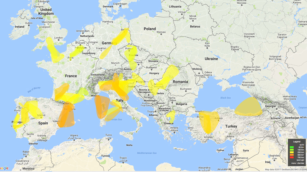 Yellow marks 250 km propagation paths
Unfortunately, Ukraine has poor APRS digipeater coverage, so on this map we stand out as a black hole. Sometimes you can see openings Kyiv–Zhytomyr–Poltava and Western Ukraine–Poland. But none of that helps southern Ukraine, sadly.
US5ZAP pointed me to AIS (Automatic Identification System). It’s a maritime system that transmits a vessel’s ID, dimensions, heading and other data over VHF. So every ship has a transmitter sending its coordinates, just like APRS. And if you have coordinates, you can work out the communication range.
As UR5ZBV noted, if there’s propagation on these frequencies, there’s propagation on 2 meters too.
I’d already started looking at AIS receivers and thinking about where to put yet another antenna, since AIS runs on frequencies different from those of typical 2 m VHF antennas:
морской канал 87B (AIS A) - частота 161.975Mhz
морской канал 88B (AIS B) - частота 162.025Mhz
Then I remembered there’s http://marinetraffic.com/, where you can track ship movements. If you find the AIS receiving station nearest to you, you can see its packet reception statistics, for example for Mykolaiv, station 517.
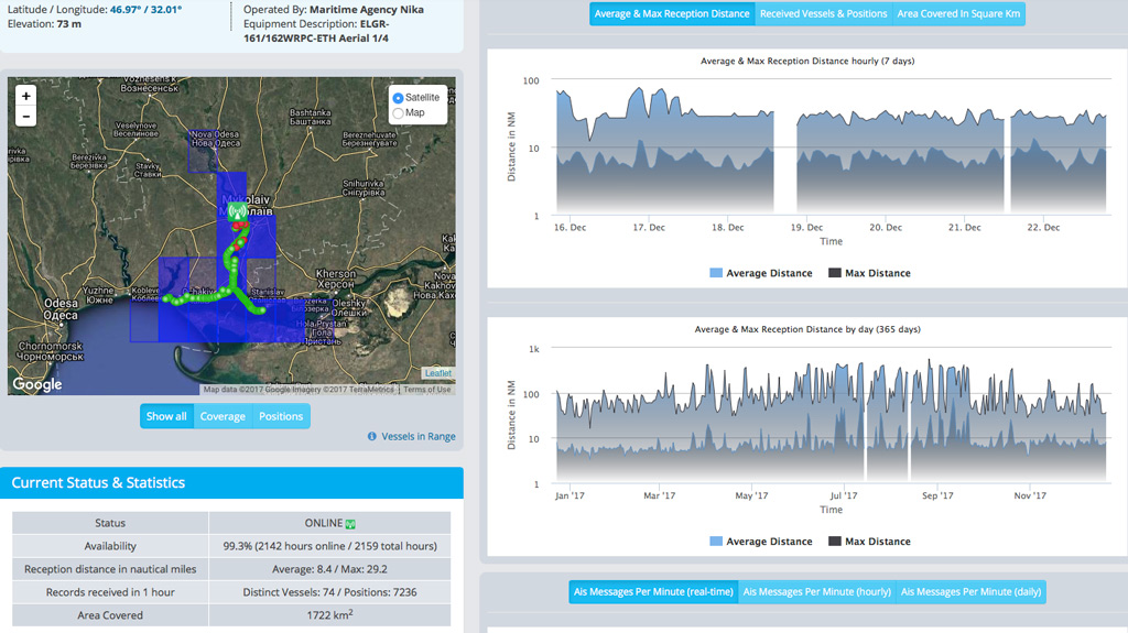 Screenshot as of December 22, 2017
So what’s useful for us here? Reception distance in nautical miles Average: 8.4 / Max: 29.2
That is, the most distant signal this AIS station received was 29.2 nautical miles away (29.2 × 1.852 ≈ 54 km). For us that’s solid reception of the Kherson R7 repeater with an antenna at 73 m, like this station has :-) The blue squares on the map also show the AIS station’s coverage area for today: 1722 km².
The 365-day history chart clearly shows the range growing in summer. On some days it reached 336 nautical miles, about 622 km, which makes the theory plausible.
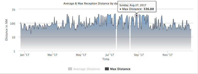 Screenshot as of December 22, 2017
You could also guess that there’s no point expecting very long, very stable openings, beyond 180–200 km, before March. Well, we’ll see.
If anyone wants to build a Telegram or email bot that sends alerts when AIS reception range goes up, here’s the link to the AIS station data in JSON: https://www.marinetraffic.com/en/ais/getchart/stationsCharts/517. The field to look at is
"hourly"..."max_h":[[1513371480000,59.44],[1513375080000,67.85],[1513378680000,59.36],[1513382280000,54.34],[1513385880000,28.94],[1513389480000,24.56]...
If anyone wants to set up their own AIS receiver, check out the range from this Ukrainian manufacturer: http://electronic-gallery.com.ua/index.php?target=product&cat=17. You can feed the data to http://aishub.net/ or http://marinetraffic.com/, and it will show up on the map for everyone to see.
But putting up APRS digirepeaters is the better option.
UPDATE: You can look up FM stations in your area on a given frequency here: https://fmscan.org/main.php?f=106